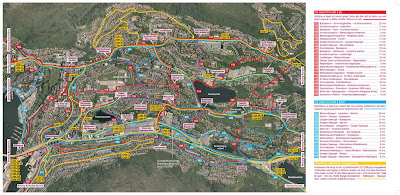
 This map shows the connecting routes by bus or by bike in the north end of the Bergen valley, close to the city center. Access point : Wergeland is situated in the middle of the picture. Though this map is outdated due to missing cycle-paths after the light rail line is buildt it can be an interesting study to see the access routes from Wergeland connecting to these. And how will the routes change when the light rail is in traffic? How does the intensity map look like?
torsdag 25. mars 2010
CYCLE WALK (BUS)RIDE IN THE VALLEY OF BERGEN
 This map shows the connecting routes by bus or by bike in the north end of the Bergen valley, close to the city center. Access point : Wergeland is situated in the middle of the picture. Though this map is outdated due to missing cycle-paths after the light rail line is buildt it can be an interesting study to see the access routes from Wergeland connecting to these. And how will the routes change when the light rail is in traffic? How does the intensity map look like?
Etiketter:
::accessibility
Abonner på:
Legg inn kommentarer (Atom)

our+alternative+legacy-01.png)

Ingen kommentarer:
Legg inn en kommentar